当前位置: 首页> 专利交易> 详情页
    待售中

    一种车位地图生成方法、装置、设备及存储介质[ZH]

    专利编号: ZL202609180124

    收藏

    拟转化方式: 转让;普通许可;独占许可;排他许可;开放许可

    交易价格:面议

    专利类型:发明专利

    法律状态:授权

    技术领域:汽车相关其他

    发布日期:2026-09-18

    发布有效期: 2026-09-18 至 2042-10-10

    专利顾问 — 王老师

    电话咨询

    咨询电话

    13760886304

    专利基本信息
    >
    申请号 CN202211236083.5 公开号 CN115762218A
    申请日 2022-10-10 公开日 2023-03-07
    申请人 中汽创智科技有限公司 专利授权日期 2024-10-11
    发明人 李华东;周勋;胡伟;李建昆 专利权期限届满日 2042-10-10
    申请人地址 211100 江苏省南京市江宁区秣陵街道胜利路88号 最新法律状态 授权
    技术领域 汽车相关其他 分类号 G08G1/14
    技术效果 高效率 有效性 有效(授权、部分无效)
    专利代理机构 广州三环专利商标代理有限公司 44202 代理人 方秀琴
    专利技术详情
    >
    01

    专利摘要

    本发明公开了一种车位地图生成方法、装置、设备及存储介质,该方法包括:从车库点云深度图像确定待处理车位图像;所述待处理车位图像包括至少一个目标车位的车位图像;确定所述待处理车位图像中的至少三个图像顶点;所述至少三个图像顶点依次连接形成的路径顺序为顺时针;基于所述至少三个图像顶点在所述待处理车位图像中的位置信息,生成具有车位方向信息的待绘制车位区域;基于车位布局配置信息,在所述待绘制车位区域中绘制车位,生成车位地图;所述车位布局配置信息基于所述待处理车位图像确定;本发明能够在提高车位地图的绘制精度的情况下,保证地图的绘制效率。
    展开 >
    02

    专利详情

    技术领域

    本发明涉及数字地图领域,具体为一种车位地图生成方法、装置、设备及存储介质。

    背景技术

    当今社会背景下,停车难的痛点急需解决,停车位无法定位,空车位寻找困难,大规模高频次的停车需求,决定了智慧停车成为刚需;而车位数字化,高精地图是智慧停车的必经之路,为实现停车资源的合理分配,停车的便利性,目前市面上的单车智能,车场协同,停车机器人等方案都需要以高精地图为基础,即车位数字化和智慧停车都绕不开以高精地图。而高精地图目前在推进过程中面临生产效率低,数据可靠性和更新频率仍需提高等问题,因此如何提升高精地图的生产效率成为一个需要迫切解决的问题。

    发明内容

    为了克服现有技术存在的缺点与不足,本发明公开一种车位地图生成方法、装置、设备及存储介质,能够在提高车位地图的绘制精度的情况下,保证地图的绘制速度,该方法包括:

    从车库点云深度图像确定待处理车位图像;所述待处理车位图像包括至少一个目标车位的车位图像;

    确定所述待处理车位图像中的至少三个图像顶点;所述至少三个图像顶点依次连接形成的路径顺序为顺时针;所述至少三个图像顶点中的第一图像顶点与第二图像顶点,位于所述待处理车位图像中的相同车位出口线上;所述第二图像顶点与第三图像顶点位于所述待处理车位图像中的相同车位侧边线;所述第一图像顶点为所述至少三个图像顶点的起始顶点;

    基于所述至少三个图像顶点在所述待处理车位图像中的位置信息,生成具有车位方向信息的待绘制车位区域;

    基于车位布局配置信息,在所述待绘制车位区域中绘制车位,生成车位地图;所述车位布局配置信息基于所述待处理车位图像确定。

    更进一步地,所述车位地图包括所述至少一个目标车位对应的目标车位标识;

    所述基于车位布局配置信息,在所述待绘制车位区域中绘制车位,生成车位地图,包括:

    基于所述车位布局配置信息,在所述待绘制车位区域中绘制至少一个目标车位区域;

    在所述至少一个目标车位区域中添加目标车位标识,得到与所述待处理车位图像对应的车位地图。

    更进一步地,所述在所述至少一个目标车位区域中添加目标车位标识,得到与所述待处理车位图像对应的车位地图,包括:

    确定每个目标车位区域中目标车位标识的位置信息以及方向信息;所述方向信息使得标识在目标角度下正向展示;所述目标角度为以任一目标车位区域出口线指向所述任一目标车位区域内的角度;

    基于所述位置信息和所述方向信息添加所述目标车位标识,得到与所述待处理车位图像对应的车位地图。

    更进一步地,所述确定每个目标车位区域中目标车位标识的位置信息,包括:

    基于所述每个目标车位区域的两条侧边线,确定所述每个目标车位区域的目标中位线,所述目标中位线平行于所述两条侧边线;

    基于所述每个目标车位区域对应的目标中位线以及所述相同车位出口线,确定每个目标车位标识的位置信息,所述目标车位标识的中心点位于所述目标中位线上,所述目标车位标识与所述相同车位出口线的距离为预设长度。

    更进一步地,所述方法还包括:

    在所述待处理车位图像中目标车位的行数为两行的情况下,将所述待绘制车位区域中,与所述相同车位出口线相对的区域线确定为相对车位出口线;

    所述在所述至少一个目标车位区域中添加目标车位标识,得到与所述待处理车位图像对应的车位地图,包括:

    基于所述相同车位出口线与所述相对车位出口线,确定每个目标车位区域各自对应的目标车位出口线;

    基于所述目标车位出口线,分别确定所述每个目标车位的位置信息以及方向信息;所述方向信息使得所述目标车位标识在目标角度下正向展示;所述目标角度为以任一目标车位区域出口线指向所述任一目标车位区域内的角度;

    基于所述位置信息和所述方向信息向所述目标车位区域添加所述目标车位标识,得到与所述待处理车位图像对应的车位地图。

    更进一步地,所述方法还包括:

    在所述待处理车位图像中目标车位的行数大于两行的情况下,将每个目标车位区域中,与所述相同车位出口线平行且距离最短的车位线确定为平行车位出口线;

    所述在所述至少一个目标车位区域中添加目标车位标识,得到与所述待处理车位图像对应的车位地图,包括:

    基于每个目标车位区域各自对应的平行车位出口线,确定所述每个目标车位区域的位置信息以及方向信息;所述方向信息使得所述目标车位标识在目标角度下正向展示;所述目标角度为所述相同车位出口线指向所述任一目标车位区域内的角度;

    基于所述位置信息和所述方向信息所述目标车位区域添加所述目标车位标识,得到与所述待处理车位图像对应的车位地图。

    更进一步地,所述从车库点云深度图像确定待处理车位图像之后,所述方法还包括:

    在所述待处理车位图像为非四边形的情况下,将所述待处理车位图像划分为多个目标区域,所述多个目标区域均为四边形;

    所述确定所述待处理车位图像中的至少三个图像顶点,还包括:

    分别确定每个目标区域中的至少三个图像顶点。

    另一方面,本申请还提供一种车位地图生成装置,包括:

    第一确定模块,用于从车库点云深度图像确定待处理车位图像;所述待处理车位图像包括至少一个目标车位的车位图像;

    第二确定模块,用于确定所述待处理车位图像中的至少三个图像顶点;所述至少三个图像顶点依次连接形成的路径顺序为顺时针;所述至少三个图像顶点中的第一图像顶点与第二图像顶点,位于所述待处理车位图像中的相同车位出口线上;所述第二图像顶点与第三图像顶点位于所述待处理车位图像中的相同车位侧边线;所述第一图像顶点为所述至少三个图像顶点的起始顶点;

    生成模块,用于基于所述至少三个图像顶点在所述待处理车位图像中的位置信息,生成具有车位方向信息的待绘制车位区域;

    绘制模块,用于基于车位布局配置信息,在所述待绘制车位区域中绘制车位,生成车位地图;所述车位布局配置信息基于所述待处理车位图像确定。

    第三方面,本申请还提供一种电子设备,其特征在于,所述设备包括处理器和存储器,所述存储器中存储有至少一条指令、至少一段程序、代码集或指令集,所述至少一条指令、所述至少一段程序、所述代码集或指令集由所述处理器加载并执行以实现如上所述的一种车位地图生成方法。

    第四方面,本申请还提供一种计算机可读存储介质,所述存储介质中存储有至少一条指令、至少一段程序、代码集或指令集,所述至少一条指令、至少一段程序、代码集或指令集由处理器加载并执行如上所述的一种车位地图生成方法。

    实施本发明,具有如下有益效果:

    本申请顺时针确定待处理车位图像的三个图像顶点,根据平行线定理生成具有车位方向信息的待绘制车位区域,能够保证待绘制车位区域的绘制精度,三个图像顶点通过人为确定,准确度更高,基于车位布局配置信息在待绘制车位区域中绘制车位,实现批量化绘制地图,提高地图绘制效率,基于第一图像顶点与第二图像顶点能够准确确定出待处理车位图像的相同车位出口线,进而能够确定后续车位标识号的位置信息与方向信息,提高车位绘制精度。

    附图说明

    为了更清楚地说明本发明的技术方案,下面将对实施例或现有技术描述中所需要使用的附图作简单地介绍,显而易见地,下面描述中的附图仅仅是本发明的一些实施例,对于本领域普通技术人员来讲,在不付出创造性劳动的前提下,还可以根据这些附图获得其它附图。

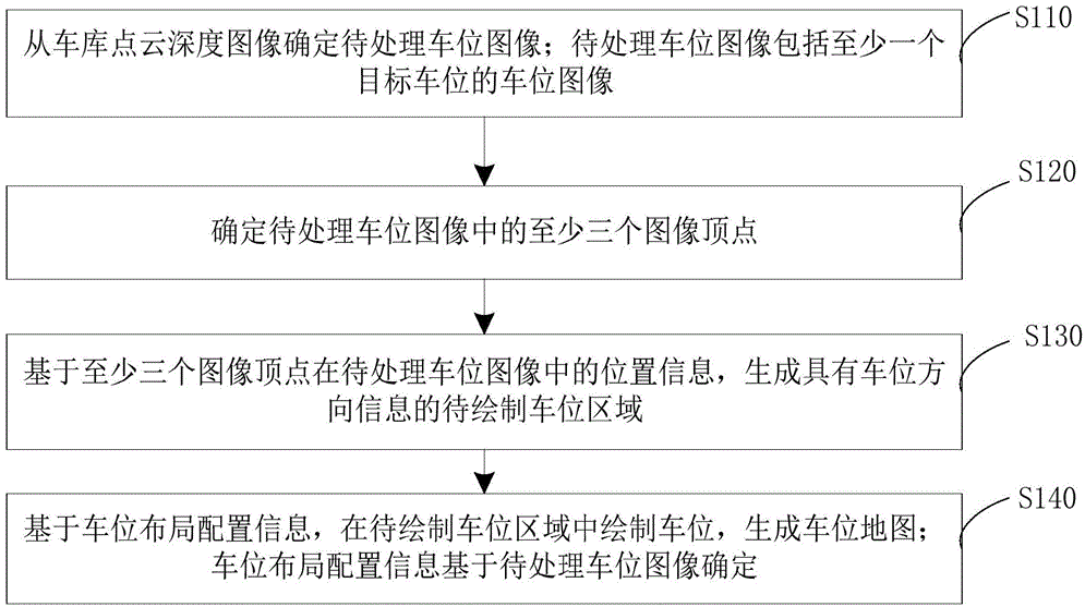
    图1为本发明实施例提供的车位地图生成方法流程图;

    图2为本发明实施例提供的第一车位地图的示意图;

    图3为本发明实施例提供的第二车位地图的示意图;

    图4为本发明实施例提供的第三车位地图的示意图;

    图5为本发明实施例提供的第四车位地图的示意图;

    图6为本发明实施例提供的第五车位地图的示意图;

    图7为本发明实施例提供车位地图生成装置。

    具体实施方式

    为了使本技术领域的人员更好地理解本申请中的技术方案,下面将结合本申请实施例中的附图,对本申请实施例中的技术方案进行清楚、完整地描述,显然,所描述的实施例仅仅是本申请一部分实施例,而不是全部的实施例。基于本申请中的实施例,本领域普通技术人员在没有作出创造性劳动前提下所获得的所有其他实施例,都应当属于本申请保护的范围。

    本实施例中,本发明所要解决的技术问题在于能够在提高车位地图的绘制精度的情况下,保证地图的绘制速度。参照图1,该方法包括:

    S110:从车库点云深度图像确定待处理车位图像;待处理车位图像包括至少一个目标车位的车位图像;

    本实施例的执行主体为服务器或者用户终端,通过激光雷达采集的点云数据经过处理入库,得到车库点云深度图像,通过3D绘图协议加载车库点云深度图像,基于javascript(解释型脚本语言)和react(Web开发框架)搭建基础工具页面,能支持用户配置停车位的行数与列数,能够参照车库点云深度图像绘制地图,一个停车位包括多个待处理图像,每个待处理图像包括至少一个目标车位的车位图像,根据目前的现有道路场景,每个待处理车位图像中的目标车分布情况分为1行1列,2行2列,1行n列,1列n行,2行n列,2列n行等场景,其中,n>2,目标车位包括常规矩形车位以及倾斜的平行四边形停车位。

    S120:确定待处理车位图像中的至少三个图像顶点;至少三个图像顶点依次连接形成的路径顺序为顺时针;至少三个图像顶点中的第一图像顶点与第二图像顶点,位于待处理车位图像中的相同车位出口线上;第二图像顶点与第三图像顶点位于待处理车位图像中的相同车位侧边线;第一图像顶点为至少三个图像顶点的起始顶点;

    一般情况下,待处理车位图像中为四边形,确定四边形至少三个图像顶点,为提高地图的绘制精度,地图绘制界面上显示车库点云深度图像,根据显示的车库点云深度图像确定待处理车位图像,在待处理车位图像的图像边缘至少确定三个图像顶点,三个图像顶点为四边形呈顺时针的三个连续顶点,第一图像顶点与第二图像顶点的连接线为待处理车位图像中的相同车位出口线,车位出口线为待处理车位图像与道路相邻的区域线,车辆进出车位过程中,首先经过的相同车位出口线,为提高车位地图绘制精度,可增加图像顶点,除待处理车位图像中的四个图像顶点之外,还可确定待处理车位图像的边缘点。

    S130:基于至少三个图像顶点在待处理车位图像中的位置信息,生成具有车位方向信息的待绘制车位区域;

    至少三个图像顶点连接,形成相同车位出口线以及相同车位侧边线,基于平行线定理,得到具有车位方向信息的待绘制车位区域,即待处理车位图像的四边形边界线,基于相同出开口线以及相同车位侧边线防线,能够确定车位方向信息,车位方向信息为指向车位出口线的方向,基于车位方向信息能够确定地图中的相关标号,如车位标识号,道路引导线。

    S140:基于车位布局配置信息,在待绘制车位区域中绘制车位,生成车位地图;车位布局配置信息基于待处理车位图像确定。

    输入车位布局配置信息,车位布局配置信息包括在待处理车位图像中目标车位的行数与列数,均衡拆分出每个目标车位,在待绘制车位区域中绘制每个目标车位,生成车位地图,车位地图具有车位方向信息,能够在基于车位方向信息在车位地图绘制相关标号,如车位标识,道路引导线,目前的自动化识别算法因为数据质量,算法识别精度等问题难以准确识别出目标车位的顶点,无法准确的识别出相同车位出口线,以及绘制完成的车位地图与实际车库场景不符等问题,无法避免人工的参与,本实施例生成具有车位方向信息的待绘制车位区域,能够保证待绘制车位区域的绘制精度,基于车位布局配置信息在待绘制车位区域中绘制车位,实现批量化绘制地图,提高地图绘制效率,基于第一图像顶点与第二图像顶点能够准确确定出待处理车位图像的相同车位出口线,进而能够确定后续车位标识号的位置信息与方向信息,提高车位绘制精度。

    在一中实施方式中,车位地图包括至少一个目标车位对应的目标车位标识;

    基于车位布局配置信息,在待绘制车位区域中绘制车位,生成车位地图,包括:

    基于车位布局配置信息,在待绘制车位区域中绘制至少一个目标车位区域;

    在至少一个目标车位区域中添加目标车位标识,得到与待处理车位图像对应的车位地图。

    每个目标车位上都绘制有对应的目标车位标识,目标车位标识为车位编号,一般情况下,查询目标车位标识的视角为站在目标车位出口线方向看向目标车位区域,因此车位标识添加的位置靠近于目标车位区域的出口线,以使用户能够清楚的观察到目标车位标识;能够便于用户查找目标车位,提高用户使用便利性。

    在一种实施方中,在至少一个目标车位区域中添加目标车位标识,得到与待处理车位图像对应的车位地图,包括:

    确定每个目标车位区域中目标车位标识的位置信息以及方向信息;方向信息使得标识在目标角度下正向展示;目标角度为以任一目标车位区域出口线指向任一目标车位区域内的角度;

    按照各待处理车位图像的先后处理顺序,依次确定目标车位区域中目标车位标识的内容,目标车位标识的内容可以以第一图像顶点所在的目标车位区域为起点,以顺时针的方向依次标号,如图2中,在第一张待处理车位图像中的第一图像顶点所在的目标车位区域的目标车位标识的内容为“001”,按顺时针的方向依次标号,至最后一个目标车位区域的目标车位标识的内容为“005”;在第二张待处理车位图像中的第一个目标车位区域的目标车位标识对应的标号为“006”,依次确定第二张待处理车位图像中各目标车位区域中目标车位标识的内容,以使每个目标车位标识的内容在该车库中不重复。

    基于位置信息和方向信息添加目标车位标识,得到与待处理车位图像对应的车位地图。

    参照图2所示的1行n列的车位地图,基于第一图像顶点、第二图像顶点以及第三图像顶点确定了具有车位方向信息的待绘制车位区域,第一图像顶点与第二图像顶点之间的连线为相同车位出口线,相应的,每个目标车位位于相同车位出口线的车位线为该目标车位的出口线,用户站在相同车位出口线方向,看向任一目标车位区域时,目标车位标识展示为正向的,在目标车位区域中添加目标车位标识,一般情况下,用户站目标车位出口线方向查询目标车位标识,因此车位标识添加的位置靠近于目标车位的出口线,以使用户能够清楚的观察到目标车位标识;目标车位标识添加的方向是用户站在目标车位的出口线处看向目标车位标识时,目标车位是正向,能够便于用户查找目标车位,上述为实际车库中车位标识的绘制方式,在车位地图中,目标车位标识与实际车位中的车位标识的位置与方向应当一致,保证车位地图与实际车位的一致性。

    在一种实施方式中,确定每个目标车位区域中目标车位标识的位置信息,包括:

    基于每个目标车位区域的两条侧边线,确定每个目标车位区域的目标中位线,目标中位线平行于两条侧边线;

    基于每个目标车位区域对应的目标中位线以及相同车位出口线,确定每个目标车位标识的位置信息,目标车位标识的中心点位于目标中位线上,目标车位标识与相同车位出口线的距离为预设长度。

    参照图2,目标车位标识一般在目标车位区域居中设置,基于目标车位区域的两条侧边线,确定目标中位线,目标中位线分别与两条侧边线的距离相等,目标车位标识的中心点位于目标中位线上,目标车位标识平行于相同车位出口线,目标车位标识与相同车位出口线的距离为预设长度,预设长度可以为零,即目标车位标识位于目标车位的出口线上,输入车位布局配置信息,再通过第一图像顶点、第二图像顶点以及第三图像顶点,可以批量化生成待绘制车位区域对应的车位地图,车位地图中包含各个目标车位区域对应的目标车位标识,通过第一图像顶点、第二图像顶点以及第三图像顶点确定目标车位标识的位置信息与方向信息,提高车位地图的绘制精度以及提高绘制地图的效率。

    在一种实施方式中,方法还包括:

    在待处理车位图像中目标车位的行数为两行的情况下,将待绘制车位区域中,与相同车位出口线相对的区域线确定为相对车位出口线;

    参照图3所示的2行n列车位地图,n>2,图中第一图像顶点与第二图像顶点之间的连线为相同车位出口线,与相同车位出口线相对的区域线确定为相对车位出口线,每个目标车位区域均有对应的出口线,位于下面一行的目标车位区域的出口线位于相同车位出口线上,位于上面一行的目标车位区域的出口线位于相对车位出口线上(图中虚线所示)。

    在至少一个目标车位区域中添加目标车位标识,得到与待处理车位图像对应的车位地图,包括:

    基于相同车位出口线与相对车位出口线,确定每个目标车位区域各自对应的目标车位出口线;

    基于目标车位出口线,分别确定每个目标车位的位置信息以及方向信息;方向信息使得目标车位标识在目标角度下正向展示;目标角度为以任一目标车位区域出口线指向任一目标车位区域内的角度;

    基于各目标车位区域对应的目标车位出口线,确定目标车位标识的位置信息以及方向信息,位置信息的确定方式:目标车位区域的两条侧边线,确定目标中位线,目标车位标识的中心点位于目标中位线上,目标车位线平行于相同车位出口线,目标车位标识与目标车位出口线的距离为预设长度,预设长度可以为零,目标车位标识位于目标车位的出口线上;方向信息使得目标车位标识在目标角度下正向展示;目标角度为以任一目标车位区域对应的目标车位出口线指向任一目标车位区域内的角度;目标车位标识的内容可以以第一图像顶点所在的目标车位区域为起点,随着顺时针的方向依次标号,即如图3中,第一图像顶点所在的目标车位区域的目标车位标识的内容为“001”,按顺时针的方向依次标号,至与“001”同行的最后一个目标车位区域的目标车位标识的内容为“005”,在“005”上方的“006”,至车位地图中最后一个目标车位区域的目标车位标识的内容为“010”。

    基于位置信息和方向信息向目标车位区域添加目标车位标识,得到与待处理车位图像对应的车位地图。

    将位置信息和方向信息向目标车位区域添加目标车位标识,在目标车位区域存在两行的情况下,能够参照实际车位情况自动生成展示方向相反的两行目标车位标识,得到与待处理车位图像对应的车位地图,提高车位地图的绘制精度以及提高绘制地图的效率。

    在一种实施方式中,方法还包括:

    在待处理车位图像中目标车位的行数大于两行的情况下,将每个目标车位区域中,与相同车位出口线平行且距离最短的车位线确定为平行车位出口线;

    参照图4所示的2列n行车位地图,图4为侧方位情况,同样可以运用在1列n行车位地图中,其中,n>2,将每个目标车位区域中,距离相同车位出口线平行且距离最短的车位线确定为平行车位出口线,即每个目标车位区域的出口线。

    在至少一个目标车位区域中添加目标车位标识,得到与待处理车位图像对应的车位地图,包括:

    基于每个目标车位区域各自对应的平行车位出口线,确定每个目标车位区域的位置信息以及方向信息;方向信息使得目标车位标识在目标角度下正向展示;目标角度为相同车位出口线指向任一目标车位区域内的角度;位置信息的确定方式:目标车位区域的两条侧边线,确定目标中位线,目标车位标识的中心点位于目标中位线上,目标车位标识平行于相同车位出口线,目标车位标识与相同车位出口线的距离为预设长度,预设长度可以为零,目标车位标识位于目标车位区域的出口线上;方向信息使得目标车位标识在目标角度下正向展示;目标角度为相同车位出口线指向任一目标车位区域内的角度;在停车位为侧方位的情况下,目标车位标识的内容可以以第一图像顶点所在的目标车位区域为起点,随着逆时针的方向依次标号,如图4中,第一图像顶点所在的目标车位区域的目标车位标识的内容为“001”,按逆时针的方向依次标号,至与“001”同列的最后一个目标车位区域的目标车位标识的内容为“003”,在“003”逆时针方向的“004”,至车位地图中最后一个目标车位区域的目标车位标识的内容为“006”。

    基于位置信息和方向信息目标车位区域添加目标车位标识,得到与待处理车位图像对应的车位地图。

    将位置信息和方向信息向目标车位区域添加目标车位标识,在目标车位区域存在多列的情况下,能够自动生成展示方向相同的所有目标车位标识,得到与待处理车位图像对应的车位地图,提高车位地图的绘制精度以及提高绘制地图的效率。

    在一种特殊的情况下,车位地图中的目标车位区域呈2行2列,需要确定两行的目标车位标识的方向信息是同向还是反向,若2行的目标车位标识的方向信息为同向,如图5所示,则将2行2列的车位地图按照2列n行,或者1列n行的方式进行处理,即将每个目标车位区域中,与相同车位出口线平行且距离最短的车位线确定为该目标车位区域的出口线,进而确定目标车位标识的位置信息与方向信息;若2行的目标车位标识的方向信息为同向,如图6所示,则将2行2列的车位地图按照2行n列的方式进行处理,即将待绘制车位区域中,与相同车位出口线相对的区域线确定为相对车位出口线,确定每个目标车位区域的目标车位出口线,进而确定目标车位标识的位置信息与方向信息。

    在一种实施方式中,从车库点云深度图像确定待处理车位图像之后,方法还包括:

    在待处理车位图像为非四边形的情况下,将待处理车位图像划分为多个目标区域,多个目标区域均为四边形;

    确定待处理车位图像中的至少三个图像顶点,还包括:

    分别确定每个目标区域中的至少三个图像顶点。

    在待处理车位图像为非四边形的情况下,即待处理车位图像中,每行和/或每列的目标车位区域数量不同,或者每行和/或每列的目标车位区域错位的情况,如待处理车位图像中包括两行两列目标车位区域,且总共有三个目标车位的情况下,将待处理车位图像划分为多个目标区域,多个目标区域均为四边形,每个目标区域分别形成待处理车位图像,在每个目标区域上分别确定至少三个图像顶点,基于至少三个图像顶点,绘制该目标区域对应的车位地图,实现车位地图多元化绘制。

    本实施还提供一种车位地图生成装置,该装置能够实现上述所有方法步骤,如图7所示,该装置包括:

    第一确定模块710,用于从车库点云深度图像确定待处理车位图像;待处理车位图像包括至少一个目标车位的车位图像;

    第二确定模块720,用于确定待处理车位图像中的至少三个图像顶点;至少三个图像顶点依次连接形成的路径顺序为顺时针;至少三个图像顶点中的第一图像顶点与第二图像顶点,位于待处理车位图像中的相同车位出口线上;第二图像顶点与第三图像顶点位于待处理车位图像中的相同车位侧边线;第一图像顶点为至少三个图像顶点的起始顶点;

    生成模块730,用于基于至少三个图像顶点在待处理车位图像中的位置信息,生成具有车位方向信息的待绘制车位区域;

    绘制模块740,用于基于车位布局配置信息,在待绘制车位区域中绘制车位,生成车位地图;车位布局配置信息基于待处理车位图像确定。

    该装置还包括:

    第一绘制模块,用于基于所述车位布局配置信息,在所述待绘制车位区域中绘制至少一个目标车位区域;所述车位地图包括所述至少一个目标车位对应的目标车位标识;

    第一添加模块,用于在所述至少一个目标车位区域中添加目标车位标识,得到与所述待处理车位图像对应的车位地图。

    第三确定模块,用于确定每个目标车位区域中目标车位标识的位置信息以及方向信息;所述方向信息使得标识在目标角度下正向展示;所述目标角度为以任一目标车位区域出口线指向所述任一目标车位区域内的角度;

    第二添加模块,用于基于所述位置信息和所述方向信息添加所述目标车位标识,得到与所述待处理车位图像对应的车位地图。

    第四确定模块,用于基于所述每个目标车位区域的两条侧边线,确定所述每个目标车位区域的目标中位线,所述目标中位线平行于所述两条侧边线;

    第五确定模块,用于基于所述每个目标车位区域对应的目标中位线以及所述相同车位出口线,确定每个目标车位标识的位置信息,所述目标车位标识的中心点位于所述目标中位线上,所述目标车位标识与所述相同车位出口线的距离为预设长度。

    第六确定模块,用于在所述待处理车位图像中目标车位的行数为两行的情况下,将所述待绘制车位区域中,与所述相同车位出口线相对的区域线确定为相对车位出口线;

    第七确定模块,用于基于所述相同车位出口线与所述相对车位出口线,确定每个目标车位区域各自对应的目标车位出口线;

    第八确定模块,用于基于所述目标车位出口线,分别确定所述每个目标车位的位置信息以及方向信息;所述方向信息使得所述目标车位标识在目标角度下正向展示;所述目标角度为以任一目标车位区域出口线指向所述任一目标车位区域内的角度;

    第三添加模块,用于基于所述位置信息和所述方向信息向所述目标车位区域添加所述目标车位标识,得到与所述待处理车位图像对应的车位地图。

    第九确定模块,用于在所述待处理车位图像中目标车位的行数大于两行的情况下,将每个目标车位区域中,与所述相同车位出口线平行且距离最短的车位线确定为平行车位出口线;

    第十确定模块,用于基于每个目标车位区域各自对应的平行车位出口线,确定所述每个目标车位区域的位置信息以及方向信息;所述方向信息使得所述目标车位标识在目标角度下正向展示;所述目标角度为所述相同车位出口线指向所述任一目标车位区域内的角度;

    第四添加模块,用于基于所述位置信息和所述方向信息所述目标车位区域添加所述目标车位标识,得到与所述待处理车位图像对应的车位地图。

    划分模块,用于在所述待处理车位图像为非四边形的情况下,将所述待处理车位图像划分为多个目标区域,所述多个目标区域均为四边形;

    第十一确定模块,用于分别确定每个目标区域中的至少三个图像顶点。

    实施本实施例,具有如下效果:

    1.本实施例顺时针确定待处理车位图像的三个图像顶点,根据平行线定理生成具有车位方向信息的待绘制车位区域,能够保证待绘制车位区域的绘制精度,三个图像顶点通过人为确定,准确度更高,基于车位布局配置信息在待绘制车位区域中绘制车位,实现批量化绘制地图,提高地图绘制效率,基于第一图像顶点与第二图像顶点能够准确确定出待处理车位图像的相同车位出口线,进而能够确定后续车位标识号的位置信息与方向信息,提高车位绘制精度。

    2.针对不同排列方式的待处理图像,用不同的方式确定目标车位区域的出口线,以此确定目标车位标识的位置信息与方向信息,能够批量绘制多种类型车位地图,提高地图生成装置的适用性。

    本发明的实施例还提供了一种电子设备,电子设备包括处理器和存储器,存储器中存储有至少一条指令、至少一段程序、代码集或指令集,至少一条指令、至少一段程序、代码集或指令集由处理器加载并执行以实现如方法实施例中的一种车位地图生成方法。

    本发明的实施例还提供了一种存储介质,存储介质可设置于服务器之中以保存用于实现方法实施例中一种车位地图生成方法的至少一条指令、至少一段程序、代码集或指令集,该至少一条指令、该至少一段程序、该代码集或指令集由该处理器加载并执行以实现上述方法实施例提供的一种车位地图生成方法。

    可选地,在本实施例中,上述存储介质可以位于计算机网络的多个网络服务器中的至少一个网络服务器。可选地,在本实施例中,上述存储介质可以包括但不限于:U盘、只读存储器(ROM,Read-Only Memory)、随机存取存储器(RAM,Random Access Memory)、移动硬盘、磁碟或者光盘等各种可以存储程序代码的介质。

    需要说明的是,本发明的说明书和权利要求书及上述附图中的术语“第一”、“第二”等是用于区别类似的对象,而不必用于描述特定的顺序或先后次序。应该理解这样使用的数据在适当情况下可以互换,以便这里描述的本发明的实施例能够以除了在这里图示或描述的那些以外的顺序实施。此外,术语“包括”和“具有”以及他们的任何变形,意图在于覆盖不排他的包含,例如,包含了一系列步骤或单元的过程、方法、系统、产品或服务器不必限于清楚地列出的那些步骤或单元,而是可包括没有清楚地列出的或对于这些过程、方法、产品或设备固有的其它步骤或单元。

    上述说明已经充分揭露了本发明的具体实施方式。需要指出的是,熟悉该领域的技术人员对本发明的具体实施方式所做的任何改动均不脱离本发明的权利要求书的范围。相应地,本发明的权利要求的范围也并不仅仅局限于前述具体实施方式。

    一种车位地图生成方法、装置、设备及存储介质

    Technical field

    The present invention relates to the field of digital maps, specifically a parking space map generation method, apparatus, equipment and storage medium.

    Background technology

    In today's social background, the pain points of parking difficulties need to be solved urgently, parking spaces cannot be located, vacant parking spaces are difficult to find, and large-scale and high-frequency parking demand determines that smart parking has become a rigid demand; In order to achieve the reasonable allocation of parking resources and the convenience of parking, the current bicycle intelligence, parking lot coordination, parking robots and other solutions on the market need to be based on high-precision maps, that is, parking space digitalization and smart parking can not be bypassed with high-precision maps. However, high-definition maps are currently facing problems such as low production efficiency, data reliability and update frequency still need to be improved, so how to improve the production efficiency of high-definition maps has become an urgent problem to be solved.

    Invention content

    In order to overcome the shortcomings and deficiencies of the prior art, the present invention discloses a parking space map generation method, apparatus, equipment and storage medium, which can improve the drawing accuracy of the parking space map, ensure the drawing speed of the map, the method comprises:

    Determine the image of the parking space to be processed from the garage point cloud depth image; The parking space image to be processed includes at least one target parking space image;

    determine at least three image vertices in the image of the parking space to be processed; At least three image vertices connected sequentially to form a path sequence clockwise; the first image vertex and the second image vertex in at least three image vertices, located on the same parking space exit line in the image of the parking space to be processed; the second image vertex and the third image vertex are located on the same parking space side edge in the parking space image to be processed; The first image vertex is the starting vertex of at least three image vertices;

    Based on the position information of at least three image vertices in the parking space image to be processed, the parking space area to be drawn with parking space direction information is generated;

    Based on the parking space layout configuration information, the parking space is drawn in the area of the parking space to be drawn to generate a parking space map; The parking space layout configuration information is determined based on the image of the parking space to be processed.

    Further, the parking space map comprises at least one target parking space corresponding to the target parking space identification;

    Based on the parking space layout configuration information, the parking space is drawn in the area of the parking space to be drawn to generate a parking space map, comprising:

    Based on the parking space layout configuration information, draw at least one target parking space area in the parking area to be drawn;

    The target parking space identification is added to at least one of the target parking space areas to obtain a parking space map corresponding to the image of the parking space to be processed.

    Further, the target parking space identification is added to at least one of the target parking space areas, and a parking space map corresponding to the image of the parking space to be processed is obtained, comprising:

    Determine the location information and direction information of the target parking space identification in each target parking area; The direction information makes the logo displayed positively at the target angle; The target angle is the angle at which the exit line of any target parking area is pointed to any target parking area;

    The target parking space identification is added based on the location information and the direction information, and the parking space map corresponding to the parking space image to be processed is obtained.

    Further, the location information that determines the target parking space identification in each target parking area comprising:

    Based on the two side lines of each target parking area, the target median line of each target parking area is determined, and the target median line is parallel to the two side lines;

    Based on the target median line corresponding to each target parking area and the same parking space exit line, the location information of each target parking space identification is determined, the center point of the target parking space identification is located on the target median line, and the distance between the target parking space identification and the same parking space exit line is a preset length.

    Further, the method further comprises:

    In the case that the number of rows of the target parking space in the image of the parking space to be processed is two lines, the area line opposite the exit line of the same parking space in the area of the parking space to be drawn is determined to be the relative parking space exit line;

    The target parking space identification is added to at least one of the target parking space areas, and a parking space map corresponding to the image of the parking space to be processed is obtained, comprising:

    Based on the same parking space exit line and the relative parking space exit line, determine the target parking space exit line corresponding to each target parking space area;

    Based on the exit line of the target parking space, the location information and direction information of each target parking space are determined respectively; The direction information makes the target parking space identification displayed positively at the target angle; The target angle is the angle at which the exit line of any target parking area is pointed to any target parking area;

    Based on the location information and the direction information, the target parking space identification is added to the target parking area, and the parking space map corresponding to the parking space image to be processed is obtained.

    Further, the method further comprises:

    In the case that the number of rows of the target parking space in the image of the parking space to be processed is greater than two lines, the parking space line parallel to the same parking space exit line and the shortest distance in each target parking space area is determined to be a parallel parking space exit line;

    The target parking space identification is added to at least one of the target parking space areas, and a parking space map corresponding to the image of the parking space to be processed is obtained, comprising:

    Based on the corresponding parallel parking space exit line of each target parking area, determine the location information and direction information of each target parking area; The direction information makes the target parking space identification displayed positively at the target angle; The target angle is the angle at which the same parking space exit line points to the area of any target parking space;

    The target parking space identification is added based on the location information and the direction information of the target parking area, and the parking space map corresponding to the parking space image to be processed is obtained.

    Further, after determining the parking space image to be processed from the garage point cloud depth image, the method further comprises:

    In the case that the parking space image to be processed is non-quadrilateral, the image of the parking space to be processed is divided into a plurality of target areas, and the plurality of target areas are quadrilaterals;

    The determining at least three image vertices in the image of the parking space to be processed, further comprising:

    Identify at least three image vertices in each target region separately.

    On the other hand, the present application also provides a parking space map generation device, comprising:

    The first determination module is used to determine the image of the parking space to be processed from the garage point cloud depth image; The parking space image to be processed includes at least one target parking space image;

    a second determination module for determining at least three image vertices in the image of the parking space to be processed; At least three image vertices connected sequentially to form a path sequence clockwise; the first image vertex and the second image vertex in at least three image vertices, located on the same parking space exit line in the image of the parking space to be processed; the second image vertex and the third image vertex are located on the same parking space side edge in the parking space image to be processed; The first image vertex is the starting vertex of at least three image vertices;

    a generation module for generating the parking space area to be drawn with parking direction information based on the position information of at least three image vertices in the parking space image to be processed;

    Drawing module, for drawing parking spaces in the area of the parking space to be drawn based on the parking space layout configuration information, and generating a parking space map; The parking space layout configuration information is determined based on the image of the parking space to be processed.

    Thirdly, the present application also provides an electronic device, wherein the device comprises a processor and a memory, the memory stores at least one instruction, at least one piece of program, code set or instruction set, at least one instruction, at least one paragraph of program, the code set or instruction set is loaded and executed by the processor to achieve a parking space map generation method described above.

    In a fourth aspect, the present application also provides a computer-readable storage medium, the storage medium is stored with at least one instruction, at least one program, code set or instruction set, at least one instruction, at least one program, code set or instruction set is loaded by the processor and performs a parking space map generation method described above.

    Implementation of the present invention, has the following beneficial effects:

    The present application determines clockwise the three image vertices of the parking space image to be processed, generates the parking space area to be drawn with parking space direction information according to the parallel line theorem, can ensure the drawing accuracy of the parking space area to be drawn, the three image vertices are artificially determined, the accuracy is higher, based on the parking space layout configuration information in the parking space area to be drawn, the parking space is drawn in batch, the map drawing efficiency is improved, and the same parking space exit line of the parking space image to be processed can be accurately determined based on the first image vertex and the second image vertex, In addition, the position information and direction information of the subsequent parking space identification number can be determined to improve the accuracy of parking space drawing.

    Description of the drawings

    In order to more clearly illustrate the technical solution of the present invention, the following will be a brief introduction to the drawings required in the embodiment or prior art description, obviously, the drawings described below are only some embodiments of the present invention, for those of ordinary skill in the art, without creative labor, may also obtain other drawings according to these drawings.

    FIG 1 is a flowchart of the parking space map generation method provided by an embodiment of the present invention;

    FIG 2 is a schematic diagram of the first parking space map provided by an embodiment of the present invention;

    FIG 3 is a schematic diagram of a second parking space map provided by an embodiment of the present invention;

    FIG 4 is a schematic diagram of a third parking space map provided by an embodiment of the present invention;

    FIG 5 is a schematic diagram of the fourth parking space map provided by an embodiment of the present invention;

    FIG 6 is a schematic diagram of the fifth parking space map provided by an embodiment of the present invention;

    FIG 7 provides a parking space map generation device for an embodiment of the present invention.

    Specific embodiment

    In order to enable persons in the art to better understand the technical solution in the present application, the following will be combined with the accompanying drawings in the present application embodiment, the technical solution in the present application embodiment is clearly and completely described, obviously, the described embodiment is only a part of the present application embodiment, not all embodiments. Based on the embodiments in the present application, all other embodiments obtained by those of ordinary skill in the art without performing creative labor shall fall within the scope of protection of the present application.

    In the present embodiment, the technical problem to be solved by the present invention is to be able to improve the drawing accuracy of the parking space map, while ensuring the drawing speed of the map. Referring to Figure 1, the method comprises:

    S110: Determine the image of the parking space to be processed from the garage point cloud depth image; The image of the parking space to be processed includes an image of the parking space of at least one target parking space;

    The main body of the present embodiment is a server or user terminal, the point cloud data collected by lidar is processed into the warehouse, the garage point cloud depth image is obtained, the garage point cloud depth image is loaded through the 3D drawing protocol, and the basic tool page is built based on JavaScript (interpreted scripting language) and react (web development framework), which can support the user to configure the number of rows and columns of the parking space, and can draw a map with reference to the garage point cloud depth image, and a parking space includes multiple images to be processed, Each image to be processed includes at least one parking space of the target parking space image, according to the current existing road scene, the target car distribution in each space image to be processed is divided into 1 row 1 column, 2 rows 2 columns, 1 row n column, 1 column n row, 2 rows n rows, 2 rows n rows and other scenes, wherein n>2, the target parking space includes a conventional rectangular parking space and an inclined parallelogram parking space.

    S120: Determine at least three image vertices in the image of the parking space to be processed; At least three image vertices are connected sequentially to form a clockwise path order; The first image vertex and the second image vertex of at least three image vertices, located on the same parking space exit line in the parking space image to be processed; The second image vertex and the third image vertex are located on the same parking space side edge in the parking space image to be processed; The first image vertex is the starting vertex of at least three image vertices;

    In general, the image of the parking space to be processed is a quadrilateral, determine at least three image vertices of the quadrangle, in order to improve the drawing accuracy of the map, the garage point cloud depth image is displayed on the map drawing interface, the parking space image to be processed is determined according to the displayed garage point cloud depth image, at least three image vertices are determined at the image edge of the parking space image to be processed, the three image vertices are three consecutive vertices of the quadrilateral clockwise, and the connection line between the first image vertex and the second image vertex is the same parking space exit line in the parking space image to be processed. The parking space exit line is the area line adjacent to the road of the parking space image to be processed, the vehicle enters and exits the parking space, the same parking space exit line that first passes, in order to improve the accuracy of parking space mapping, the image vertex can be increased, in addition to the four image vertices in the parking space image to be processed, the edge point of the parking space image to be processed can also be determined.

    S130: Based on the position information of at least three image vertices in the parking space image to be processed, the parking space area to be drawn with parking direction information is generated;

    At least three image vertices are connected to form the same parking space exit line and the same parking space side edge line, based on the parallel line theorem, the parking space area to be drawn with parking space direction information is obtained, that is, the quadrilateral boundary line of the parking space image to be processed, based on the same exit opening line and the same parking space side edge line defense line, can determine the parking space direction information, parking space direction information is the direction pointing to the parking space exit line, based on the parking space direction information can determine the relevant numbers in the map, such as parking space identification numbers, road guidance lines.

    S140: Based on the parking space layout configuration information, draw the parking space in the area to be drawn and generate a parking space map; The parking space layout configuration information is determined based on the image of the parking space to be processed.

    Enter parking space layout configuration information, parking space layout configuration information includes the number of rows and columns of the target parking space in the image of the parking space to be processed, evenly split out each target parking space, draw each target parking space in the parking space area to be drawn, generate parking space map, parking space map has parking direction information, can be based on parking space direction information in the parking space map to draw relevant labels, such as parking space identification, road guide line, the current automatic recognition algorithm because of data quality, algorithm recognition accuracy and other problems are difficult to accurately identify the vertex of the target parking space , can not accurately identify the same parking space exit line, and the completed parking space map does not match the actual garage scene and other problems, can not avoid manual participation, the present embodication generates the parking space area to be drawn with parking space direction information, can ensure the drawing accuracy of the parking space area to be drawn, based on the parking space layout configuration information in the parking space area to be drawn to draw parking spaces, to achieve batch mapping and improve map drawing efficiency, Based on the vertex of the first image and the vertex of the second image, the same parking space exit line of the parking space image to be processed can be accurately determined, and then the position information and direction information of the subsequent parking space identification number can be determined, and the parking space drawing accuracy can be improved.

    In an embodiment, the parking space map includes at least one target parking space corresponding to the target parking space identification;

    Based on the parking space layout configuration information, draw parking spaces in the area of parking spaces to be drawn and generate parking space maps, including:

    Based on the parking space layout configuration information, draw at least one target parking space area in the parking area to be drawn;

    Add target parking space identification in at least one target parking area to obtain a parking space map corresponding to the image of the parking space to be processed.

    Each target parking space is drawn with the corresponding target parking space identification, the target parking space identification is the parking space number, in general, the perspective of querying the target parking space identification is to stand in the direction of the target parking space exit line to look at the target parking space area, so the parking space identification is added close to the exit line of the target parking area, so that the user can clearly observe the target parking space identification; It can facilitate users to find the target parking space and improve the convenience of users.

    In one embodiment, the target parking space identification is added to at least one target parking area to obtain a parking space map corresponding to the image of the parking space to be processed, comprising:

    Determine the location information and direction information of the target parking space identification in each target parking area; The orientation information makes the logo display positively at the target angle; The target angle is the angle at which the exit line of any target parking area points to any target parking area;

    According to the order of processing of each parking space image to be processed, the content of the target parking space identification in the target parking area is determined in turn, and the content of the target parking space identification can be taken as the starting point of the target parking space area where the first image vertex is located, and the content of the target parking space identification in the target parking area where the first image vertex of the first parking space image to be processed is "001", and the content of the target parking space identification to the last target parking space area is marked in a clockwise direction “005”; In the target parking space identification of the first target parking space area in the second parking space image to be treated, the corresponding label is "006", and the content of the target parking space identification in each target parking area in the second target parking space image is determined in turn, so that the content of each target parking space identification is not repeated in the garage.

    Based on location information and direction information, the target parking space identification is added to obtain the parking space map corresponding to the parking space image to be processed.

    Referring to the parking space map of 1 row n columns shown in Figure 2, based on the first image vertex, the second image vertex and the third image vertex to determine the parking space area to be drawn with parking space direction information, the connection between the first image vertex and the second image vertex is the same parking space exit line, correspondingly, the parking space line of each target parking space located in the same parking space exit line is the exit line of the target parking space, the user stands in the direction of the same parking space exit line, when looking at any target parking space area, the target parking space identification is displayed as positive. Add the target parking space identification in the target parking space area, under normal circumstances, the user station query the target parking space identification in the direction of the exit line, so the location of the parking space identification added is close to the exit line of the target parking space, so that the user can clearly observe the target parking space identification; The direction of the target parking space identification is that the user stands at the exit line of the target parking space when looking at the target parking space identification, the target parking space is positive, which can facilitate the user to find the target parking space, the above is the actual garage parking space identification drawing method, in the parking space map, the target parking space identification and the actual parking space in the parking space identification position and direction should be consistent, to ensure the consistency of the parking space map and the actual parking space.

    In one embodiment, determining the location information of the target parking space identification in each target parking area, comprising:

    Based on the two side lines of each target parking area, the target median line of each target parking area is determined, and the target median line is parallel to the two side lines.

    Based on the target median line corresponding to each target parking area and the exit line of the same parking space, the location information of each target parking space identification is determined, the center point of the target parking space identification is located on the target median position, and the distance between the target parking space identification and the same parking space exit line is a preset length.

    Referring to Figure 2, the target parking space identification is generally set in the center of the target parking area, based on the two side lines of the target parking space area, determine the target median line, the target median line is equal to the distance between the two side lines, the center point of the target parking space identification is located on the target median line, the target parking space logo is parallel to the same parking space exit line, the distance between the target parking space logo and the same parking space exit line is a preset length, the preset length can be zero, that is, the target parking space logo is located on the exit line of the target parking space, enter the parking space layout configuration information, Then through the first image vertex, the second image vertex and the third image vertex, the parking space map corresponding to the parking space area to be drawn can be generated in batches, and the parking space map contains the target parking space identification corresponding to each target parking space area, and the location information and direction information of the target parking space identification are determined through the first image vertex, the second image vertex and the third image vertex, so as to improve the drawing accuracy of the parking space map and improve the efficiency of drawing the map.

    In one embodiment, the method further comprises:

    When the number of rows of the target parking space in the image of the parking space to be processed is two lines, the area line opposite to the exit line of the same parking space in the parking space area to be drawn is determined as the relative parking space exit line;

    Referring to the 2-row n train space map shown in Figure 3, n>2, the connection line between the first image vertex and the second image vertex in the figure is the same parking space exit line, and the area line opposite the same parking space exit line is determined as the relative parking space exit line, each target parking area has a corresponding exit line, the exit line of the target parking area located in the lower row is located on the same parking space exit line, and the exit line of the target parking area located in the upper row is located on the opposite parking space exit line (shown by the dotted line in the figure).

    Add target parking space identification to at least one target parking area to obtain a parking space map corresponding to the image of the parking space to be processed, including:

    Based on the same parking space exit line and the opposite parking space exit line, determine the target parking space exit line corresponding to each target parking space area;

    Based on the exit line of the target parking space, determine the location information and direction information of each target parking space respectively; The direction information makes the target parking space sign display positively at the target angle; The target angle is the angle at which the exit line of any target parking area points to any target parking area;

    Based on the target parking space exit line corresponding to each target parking space area, determine the location information and direction information of the target parking space identification, and the location information is determined in a way that: the two side lines of the target parking space area determine the target median line, the center point of the target parking space identification is located on the target median line, the target parking space line is parallel to the same parking space exit line, the distance between the target parking space logo and the target parking space exit line is a preset length, the preset length can be zero, and the target parking space identification is located on the exit line of the target parking space; The direction information makes the target parking space sign display positively at the target angle; The target angle is the angle at which the exit line of the target parking space corresponding to any target parking area points to any target parking area; The content of the target parking space identification can be based on the target parking area where the first image vertex is located, and the number is marked in a clockwise direction, that is, as shown in Figure 3, the content of the target parking space identification of the target parking space area where the first image vertex is located is "001", and it is numbered in a clockwise direction, to the content of the target parking space identification of the last target parking area traveling with "001" is "005", and "006" above "005", The content of the target parking space identification to the last target parking area in the parking space map is "010".

    Based on the location information and direction information, the target parking space identification is added to the target parking space area, and the parking space map corresponding to the parking space image to be processed is obtained.

    Add the target parking space identification to the target parking space area with location information and direction information, and when there are two rows in the target parking space area, the target parking space identification with opposite directions can be automatically generated with reference to the actual parking space situation, and the parking space map corresponding to the parking space image to be processed is obtained, which improves the drawing accuracy of the parking space map and improves the efficiency of drawing the map.

    In one embodiment, the method further comprises:

    When the number of rows of the target parking space in the image of the parking space to be processed is greater than two lines, the parking space line parallel to the same parking space exit line and the shortest distance in each target parking space area is determined as the parallel parking space exit line;

    Referring to the 2-column n-row parking space map shown in Figure 4, Figure 4 is the side orientation situation, which can also be applied to the 1-column n-row parking space map, wherein n>2, the parking space line parallel to the same parking space exit line and the shortest distance in each target parking space area is determined as the parallel parking space exit line, that is, the exit line of each target parking space area.

    Add target parking space identification to at least one target parking area to obtain a parking space map corresponding to the image of the parking space to be processed, including:

    Based on the corresponding parallel parking space exit line of each target parking area, determine the location information and direction information of each target parking area; The direction information makes the target parking space sign display positively at the target angle; The target angle is the angle at which the same parking space exit line points to any target parking space area; The determination method of location information: the two side lines of the target parking space area determine the target median line, the center point of the target parking space identification is located on the target median line, the target parking space identification is parallel to the same parking space exit line, the distance between the target parking space identification and the same parking space exit line is the preset length, the preset length can be zero, and the target parking space identification is located on the exit line of the target parking space area; The direction information makes the target parking space sign display positively at the target angle; The target angle is the angle at which the same parking space exit line points to any target parking space area; In the case of the parking space as the side orientation, the content of the target parking space identification can be based on the target parking area where the first image vertex is located, and the number is marked in turn with the counterclockwise direction, as shown in Figure 4, the content of the target parking space identification of the target parking space area where the first image vertex is located is "001", and it is numbered in reverse clockwise direction, to the content of the target parking space identification of the last target parking area in the same column as "001" is "003", and "004" in the counterclockwise direction of "003", The target parking space ID to the last target parking area in the parking space map is "006".

    Based on the location information and direction information, the target parking space identification is added to obtain the parking space map corresponding to the parking space image to be processed.

    The location information and direction information add the target parking space identification to the target parking space area, and when there are multiple columns in the target parking space area, all the target parking space signs with the same direction can be automatically generated to obtain the parking space map corresponding to the parking space image to be processed, which improves the drawing accuracy of the parking space map and improves the efficiency of drawing the map.

    In a special case, the target parking area in the parking space map is 2 rows and 2 columns, it is necessary to determine whether the direction information of the target parking space identification of the two rows is the same direction or reverse, if the direction information of the target parking space identification of the 2 rows is the same direction, as shown in Figure 5, the parking space map of 2 rows and 2 columns is processed in the way of 2 columns n rows, or 1 column n rows, that is, in each target parking area, the parking space line parallel to the same parking space exit line and the shortest distance is determined as the exit line of the target parking area. Then determine the location information and direction information of the target parking space mark; If the direction information of the target parking space identification of 2 rows is codirectional, as shown in Figure 6, the parking space map of 2 rows and 2 columns is processed according to the method of 2 rows and N columns, that is, the area line opposite to the exit line of the same parking space in the parking space area to be drawn is determined as the relative parking space exit line, and the target parking space exit line of each target parking space area is determined, and then the location information and direction information of the target parking space identification are determined.

    In one embodiment, after determining the parking space image to be processed from the garage point cloud depth image, the method further comprises:

    In the case that the image of the parking space to be processed is non-quadrilateral, the image of the parking space to be processed is divided into multiple target areas, and multiple target areas are quadrilaterals;

    Identify at least three image vertices in the image of the parking space to be processed, including:

    Identify at least three image vertices in each target region separately.

    In the case that the image of the parking space to be processed is non-quadrilateral, that is, in the parking space image to be processed, the number of target parking areas in each row and/or column is different, or the target parking area of each row and/or column is misaligned, such as the parking space image to be processed includes two rows and two columns of target parking areas, and there are a total of three target parking spaces, the parking space image to be processed is divided into multiple target areas, multiple target areas are quadrilateral, and each target area forms a parking space image to be processed. Determine at least three image vertices on each target area, and draw the parking space map corresponding to the target area based on at least three image vertices to realize diversified drawing of parking space maps.

    The present implementation also provides a parking space map generation device, the device is capable of implementing all of the above method steps, as shown in FIG. 7, the device comprising:

    First determination module 710 for determining the image of the parking space to be processed from the garage point cloud depth image; The image of the parking space to be processed includes an image of the parking space of at least one target parking space;

    a second determination module 720 for determining at least three image vertices in the image of the parking space to be processed; At least three image vertices are connected sequentially to form a clockwise path order; The first image vertex and the second image vertex of at least three image vertices, located on the same parking space exit line in the parking space image to be processed; The second image vertex and the third image vertex are located on the same parking space side edge in the parking space image to be processed; The first image vertex is the starting vertex of at least three image vertices;

    Generation module 730, for generating the parking space area to be drawn having parking direction information based on the position information of at least three image vertices in the parking space image to be processed;

    Drawing module 740, for drawing parking spaces in the area of parking spaces to be drawn based on parking space layout configuration information, generating parking space maps; The parking space layout configuration information is determined based on the image of the parking space to be processed.

    The installation also includes:

    the first drawing module is used to draw at least one target parking area in the parking space area to be drawn based on the parking space layout configuration information; The parking space map includes at least one target parking space corresponding to the target parking space identification;

    The first addition module is used to add the target parking space identification in at least one target parking area, and obtain a parking space map corresponding to the parking space image to be processed.

    The third determination module is used to determine the location information and direction information of the target parking space identification in each target parking area; The direction information makes the logo displayed positively at the target angle; The target angle is the angle at which the exit line of any target parking area is pointed to any target parking area;

    The second addition module is configured to add the target parking space identification based on the location information and the direction information, and obtain the parking space map corresponding to the parking space image to be processed.

    a fourth determination module, configured to determine the target median line of each target parking area based on the two side lines of each target parking area, and the target median line is parallel to the two side lines;

    The fifth determination module is configured to determine the location information of each target parking space identification based on the target median line corresponding to each target parking area and the same parking space exit line, the center point of the target parking space identification is located on the target median line, and the distance between the target parking space identification and the same parking space exit line is a preset length.

    The sixth determination module is used to determine the area line opposite to the same parking space exit line in the parking space area to be drawn as the relative parking space exit line when the number of rows of the target parking space in the image of the parking space to be processed is two lines;

    The seventh determination module is used to determine the corresponding target parking space exit line of each target parking space area based on the same parking space exit line and the opposite parking space exit line;

    The eighth determination module is used to determine the location information and direction information of each target parking space respectively based on the target parking space exit line; The direction information makes the target parking space identification displayed positively at the target angle; The target angle is the angle at which the exit line of any target parking area is pointed to any target parking area;

    The third addition module is configured to add the target parking space identification to the target parking space area based on the location information and the direction information, and obtain the parking space map corresponding to the parking space image to be processed.

    the ninth determination module, for determining the parking space exit line parallel to the same parking space exit line and the shortest distance in each target parking space area as a parallel parking space exit line when the number of rows of the target parking space in the parking space image to be processed is greater than two lines;

    The tenth determination module is used to determine the location information and direction information of each target parking area based on the corresponding parallel parking space exit line of each target parking area; The direction information makes the target parking space identification displayed positively at the target angle; The target angle is the angle at which the same parking space exit line points to the area of any target parking space;

    The fourth addition module is configured to add the target parking space identification based on the location information and the direction information of the target parking area, and obtain the parking space map corresponding to the parking space image to be processed.

    a division module for dividing the parking space image to be processed into a plurality of target areas when the parking space image to be processed is non-quadrilateral, and the plurality of target areas are quadrilaterals;

    Eleventh determination module, which determines at least three image vertices in each target region separately.

    Implementation of the present embodiment, has the following effects:

    1. The present embodiment determines clockwise the three image vertices of the parking space image to be processed, and generates the parking space area to be drawn with parking space direction information according to the parallel line theorem, which can ensure the drawing accuracy of the parking space area to be drawn, the three image vertices are artificially determined, the accuracy is higher, and the parking space is drawn in the parking space area to be drawn based on the parking space layout configuration information, so as to realize batch mapping and improve map drawing efficiency, Based on the vertex of the first image and the vertex of the second image, the same parking space exit line of the parking space image to be processed can be accurately determined, and then the position information and direction information of the subsequent parking space identification number can be determined, and the parking space drawing accuracy can be improved.

    2. According to the images to be processed in different arrangements, the exit line of the target parking area is determined in different ways, so as to determine the location information and direction information of the target parking space identification, and can draw a variety of types of parking space maps in batches to improve the applicability of the map generation device.

    Embodiments of the present invention also provide an electronic device, the electronic device includes a processor and a memory, the memory stores at least one instruction, at least one piece of program, code set or instruction set, at least one instruction, at least one paragraph of program, code set or instruction set loaded by the processor and executed to achieve a parking space map generation method as in the method embodiment.

    Embodiments of the present invention also provide a storage medium, the storage medium may be disposed in a server to store at least one instruction, at least one paragraph, code set or instruction set for implementing a parking space map generation method in an embodiment of the method, the at least one instruction, at least one paragraph of program, the code set or instruction set is loaded and executed by the processor to achieve a parking space map generation method provided by the embodiment of the above method.

    Optionally, in the present embodiment, the storage medium may be located in at least one network server of a plurality of network servers of the computer network. Optionally, in the present embodiment, the above storage media may include, but are not limited to: U disk, read-only memory (ROM, Read-Only Memory), random access memory (RAM, Random Access Memory), portable hard disk, disk or optical disc and other media that can store program code.

    It should be noted that the description and claims of the present invention and the terms "first", "second", etc. in the above drawings are used to distinguish similar objects, and do not have to be used to describe a particular order or sequence. It should be understood that the data so used may be interchangeable where appropriate so that the embodiments of the present invention described herein may be embodied in an order other than those illustrated or described herein. Further, the terms "including" and "having" and any variation thereof are intended to cover non-exclusive inclusions, for example, a process, method, system, product or service apparatus comprising a series of steps or units need not be limited to those steps or units expressly listed, but may include other steps or units not expressly listed or inherent to those processes, methods, products or equipment.

    The above description has fully disclosed the specific embodiments of the present invention. It should be noted that any alteration made by a person familiar with the art to a particular embodiment of the present invention does not depart from the scope of the claims of the present invention. Accordingly, the scope of the claims of the present invention is not limited to the foregoing embodiments.

    Parking space map generation method and device, equipment and storage medium

    Technical field

    The present invention relates to the field of digital maps, specifically a parking space map generation method, apparatus, equipment and storage medium.

    Background technology

    In today's social background, the pain points of parking difficulties need to be solved urgently, parking spaces cannot be located, vacant parking spaces are difficult to find, and large-scale and high-frequency parking demand determines that smart parking has become a rigid demand; In order to achieve the reasonable allocation of parking resources and the convenience of parking, the current bicycle intelligence, parking lot coordination, parking robots and other solutions on the market need to be based on high-precision maps, that is, parking space digitalization and smart parking can not be bypassed with high-precision maps. However, high-definition maps are currently facing problems such as low production efficiency, data reliability and update frequency still need to be improved, so how to improve the production efficiency of high-definition maps has become an urgent problem to be solved.

    Invention content

    In order to overcome the shortcomings and deficiencies of the prior art, the present invention discloses a parking space map generation method, apparatus, equipment and storage medium, which can improve the drawing accuracy of the parking space map, ensure the drawing speed of the map, the method comprises:

    Determine the image of the parking space to be processed from the garage point cloud depth image; The parking space image to be processed includes at least one target parking space image;

    determine at least three image vertices in the image of the parking space to be processed; At least three image vertices connected sequentially to form a path sequence clockwise; the first image vertex and the second image vertex in at least three image vertices, located on the same parking space exit line in the image of the parking space to be processed; the second image vertex and the third image vertex are located on the same parking space side edge in the parking space image to be processed; The first image vertex is the starting vertex of at least three image vertices;

    Based on the position information of at least three image vertices in the parking space image to be processed, the parking space area to be drawn with parking space direction information is generated;

    Based on the parking space layout configuration information, the parking space is drawn in the area of the parking space to be drawn to generate a parking space map; The parking space layout configuration information is determined based on the image of the parking space to be processed.

    Further, the parking space map comprises at least one target parking space corresponding to the target parking space identification;

    Based on the parking space layout configuration information, the parking space is drawn in the area of the parking space to be drawn to generate a parking space map, comprising:

    Based on the parking space layout configuration information, draw at least one target parking space area in the parking area to be drawn;

    The target parking space identification is added to at least one of the target parking space areas to obtain a parking space map corresponding to the image of the parking space to be processed.

    Further, the target parking space identification is added to at least one of the target parking space areas, and a parking space map corresponding to the image of the parking space to be processed is obtained, comprising:

    Determine the location information and direction information of the target parking space identification in each target parking area; The direction information makes the logo displayed positively at the target angle; The target angle is the angle at which the exit line of any target parking area is pointed to any target parking area;

    The target parking space identification is added based on the location information and the direction information, and the parking space map corresponding to the parking space image to be processed is obtained.

    Further, the location information that determines the target parking space identification in each target parking area comprising:

    Based on the two side lines of each target parking area, the target median line of each target parking area is determined, and the target median line is parallel to the two side lines;

    Based on the target median line corresponding to each target parking area and the same parking space exit line, the location information of each target parking space identification is determined, the center point of the target parking space identification is located on the target median line, and the distance between the target parking space identification and the same parking space exit line is a preset length.

    Further, the method further comprises:

    In the case that the number of rows of the target parking space in the image of the parking space to be processed is two lines, the area line opposite the exit line of the same parking space in the area of the parking space to be drawn is determined to be the relative parking space exit line;

    The target parking space identification is added to at least one of the target parking space areas, and a parking space map corresponding to the image of the parking space to be processed is obtained, comprising:

    Based on the same parking space exit line and the relative parking space exit line, determine the target parking space exit line corresponding to each target parking space area;

    Based on the exit line of the target parking space, the location information and direction information of each target parking space are determined respectively; The direction information makes the target parking space identification displayed positively at the target angle; The target angle is the angle at which the exit line of any target parking area is pointed to any target parking area;

    Based on the location information and the direction information, the target parking space identification is added to the target parking area, and the parking space map corresponding to the parking space image to be processed is obtained.

    Further, the method further comprises:

    In the case that the number of rows of the target parking space in the image of the parking space to be processed is greater than two lines, the parking space line parallel to the same parking space exit line and the shortest distance in each target parking space area is determined to be a parallel parking space exit line;

    The target parking space identification is added to at least one of the target parking space areas, and a parking space map corresponding to the image of the parking space to be processed is obtained, comprising:

    Based on the corresponding parallel parking space exit line of each target parking area, determine the location information and direction information of each target parking area; The direction information makes the target parking space identification displayed positively at the target angle; The target angle is the angle at which the same parking space exit line points to the area of any target parking space;

    The target parking space identification is added based on the location information and the direction information of the target parking area, and the parking space map corresponding to the parking space image to be processed is obtained.

    Further, after determining the parking space image to be processed from the garage point cloud depth image, the method further comprises:

    In the case that the parking space image to be processed is non-quadrilateral, the image of the parking space to be processed is divided into a plurality of target areas, and the plurality of target areas are quadrilaterals;

    The determining at least three image vertices in the image of the parking space to be processed, further comprising:

    Identify at least three image vertices in each target region separately.

    On the other hand, the present application also provides a parking space map generation device, comprising:

    The first determination module is used to determine the image of the parking space to be processed from the garage point cloud depth image; The parking space image to be processed includes at least one target parking space image;

    a second determination module for determining at least three image vertices in the image of the parking space to be processed; At least three image vertices connected sequentially to form a path sequence clockwise; the first image vertex and the second image vertex in at least three image vertices, located on the same parking space exit line in the image of the parking space to be processed; the second image vertex and the third image vertex are located on the same parking space side edge in the parking space image to be processed; The first image vertex is the starting vertex of at least three image vertices;

    a generation module for generating the parking space area to be drawn with parking direction information based on the position information of at least three image vertices in the parking space image to be processed;

    Drawing module, for drawing parking spaces in the area of the parking space to be drawn based on the parking space layout configuration information, and generating a parking space map; The parking space layout configuration information is determined based on the image of the parking space to be processed.

    Thirdly, the present application also provides an electronic device, wherein the device comprises a processor and a memory, the memory stores at least one instruction, at least one piece of program, code set or instruction set, at least one instruction, at least one paragraph of program, the code set or instruction set is loaded and executed by the processor to achieve a parking space map generation method described above.

    In a fourth aspect, the present application also provides a computer-readable storage medium, the storage medium is stored with at least one instruction, at least one program, code set or instruction set, at least one instruction, at least one program, code set or instruction set is loaded by the processor and performs a parking space map generation method described above.

    Implementation of the present invention, has the following beneficial effects:

    The present application determines clockwise the three image vertices of the parking space image to be processed, generates the parking space area to be drawn with parking space direction information according to the parallel line theorem, can ensure the drawing accuracy of the parking space area to be drawn, the three image vertices are artificially determined, the accuracy is higher, based on the parking space layout configuration information in the parking space area to be drawn, the parking space is drawn in batch, the map drawing efficiency is improved, and the same parking space exit line of the parking space image to be processed can be accurately determined based on the first image vertex and the second image vertex, In addition, the position information and direction information of the subsequent parking space identification number can be determined to improve the accuracy of parking space drawing.

    Description of the drawings

    In order to more clearly illustrate the technical solution of the present invention, the following will be a brief introduction to the drawings required in the embodiment or prior art description, obviously, the drawings described below are only some embodiments of the present invention, for those of ordinary skill in the art, without creative labor, may also obtain other drawings according to these drawings.

    FIG 1 is a flowchart of the parking space map generation method provided by an embodiment of the present invention;

    FIG 2 is a schematic diagram of the first parking space map provided by an embodiment of the present invention;

    FIG 3 is a schematic diagram of a second parking space map provided by an embodiment of the present invention;

    FIG 4 is a schematic diagram of a third parking space map provided by an embodiment of the present invention;

    FIG 5 is a schematic diagram of the fourth parking space map provided by an embodiment of the present invention;

    FIG 6 is a schematic diagram of the fifth parking space map provided by an embodiment of the present invention;

    FIG 7 provides a parking space map generation device for an embodiment of the present invention.

    Specific embodiment

    In order to enable persons in the art to better understand the technical solution in the present application, the following will be combined with the accompanying drawings in the present application embodiment, the technical solution in the present application embodiment is clearly and completely described, obviously, the described embodiment is only a part of the present application embodiment, not all embodiments. Based on the embodiments in the present application, all other embodiments obtained by those of ordinary skill in the art without performing creative labor shall fall within the scope of protection of the present application.

    In the present embodiment, the technical problem to be solved by the present invention is to be able to improve the drawing accuracy of the parking space map, while ensuring the drawing speed of the map. Referring to Figure 1, the method comprises:

    S110: Determine the image of the parking space to be processed from the garage point cloud depth image; The image of the parking space to be processed includes an image of the parking space of at least one target parking space;

    The main body of the present embodiment is a server or user terminal, the point cloud data collected by lidar is processed into the warehouse, the garage point cloud depth image is obtained, the garage point cloud depth image is loaded through the 3D drawing protocol, and the basic tool page is built based on JavaScript (interpreted scripting language) and react (web development framework), which can support the user to configure the number of rows and columns of the parking space, and can draw a map with reference to the garage point cloud depth image, and a parking space includes multiple images to be processed, Each image to be processed includes at least one parking space of the target parking space image, according to the current existing road scene, the target car distribution in each space image to be processed is divided into 1 row 1 column, 2 rows 2 columns, 1 row n column, 1 column n row, 2 rows n rows, 2 rows n rows and other scenes, wherein n>2, the target parking space includes a conventional rectangular parking space and an inclined parallelogram parking space.

    S120: Determine at least three image vertices in the image of the parking space to be processed; At least three image vertices are connected sequentially to form a clockwise path order; The first image vertex and the second image vertex of at least three image vertices, located on the same parking space exit line in the parking space image to be processed; The second image vertex and the third image vertex are located on the same parking space side edge in the parking space image to be processed; The first image vertex is the starting vertex of at least three image vertices;

    In general, the image of the parking space to be processed is a quadrilateral, determine at least three image vertices of the quadrangle, in order to improve the drawing accuracy of the map, the garage point cloud depth image is displayed on the map drawing interface, the parking space image to be processed is determined according to the displayed garage point cloud depth image, at least three image vertices are determined at the image edge of the parking space image to be processed, the three image vertices are three consecutive vertices of the quadrilateral clockwise, and the connection line between the first image vertex and the second image vertex is the same parking space exit line in the parking space image to be processed. The parking space exit line is the area line adjacent to the road of the parking space image to be processed, the vehicle enters and exits the parking space, the same parking space exit line that first passes, in order to improve the accuracy of parking space mapping, the image vertex can be increased, in addition to the four image vertices in the parking space image to be processed, the edge point of the parking space image to be processed can also be determined.

    S130: Based on the position information of at least three image vertices in the parking space image to be processed, the parking space area to be drawn with parking direction information is generated;

    At least three image vertices are connected to form the same parking space exit line and the same parking space side edge line, based on the parallel line theorem, the parking space area to be drawn with parking space direction information is obtained, that is, the quadrilateral boundary line of the parking space image to be processed, based on the same exit opening line and the same parking space side edge line defense line, can determine the parking space direction information, parking space direction information is the direction pointing to the parking space exit line, based on the parking space direction information can determine the relevant numbers in the map, such as parking space identification numbers, road guidance lines.

    S140: Based on the parking space layout configuration information, draw the parking space in the area to be drawn and generate a parking space map; The parking space layout configuration information is determined based on the image of the parking space to be processed.

    Enter parking space layout configuration information, parking space layout configuration information includes the number of rows and columns of the target parking space in the image of the parking space to be processed, evenly split out each target parking space, draw each target parking space in the parking space area to be drawn, generate parking space map, parking space map has parking direction information, can be based on parking space direction information in the parking space map to draw relevant labels, such as parking space identification, road guide line, the current automatic recognition algorithm because of data quality, algorithm recognition accuracy and other problems are difficult to accurately identify the vertex of the target parking space , can not accurately identify the same parking space exit line, and the completed parking space map does not match the actual garage scene and other problems, can not avoid manual participation, the present embodication generates the parking space area to be drawn with parking space direction information, can ensure the drawing accuracy of the parking space area to be drawn, based on the parking space layout configuration information in the parking space area to be drawn to draw parking spaces, to achieve batch mapping and improve map drawing efficiency, Based on the vertex of the first image and the vertex of the second image, the same parking space exit line of the parking space image to be processed can be accurately determined, and then the position information and direction information of the subsequent parking space identification number can be determined, and the parking space drawing accuracy can be improved.

    In an embodiment, the parking space map includes at least one target parking space corresponding to the target parking space identification;

    Based on the parking space layout configuration information, draw parking spaces in the area of parking spaces to be drawn and generate parking space maps, including:

    Based on the parking space layout configuration information, draw at least one target parking space area in the parking area to be drawn;

    Add target parking space identification in at least one target parking area to obtain a parking space map corresponding to the image of the parking space to be processed.

    Each target parking space is drawn with the corresponding target parking space identification, the target parking space identification is the parking space number, in general, the perspective of querying the target parking space identification is to stand in the direction of the target parking space exit line to look at the target parking space area, so the parking space identification is added close to the exit line of the target parking area, so that the user can clearly observe the target parking space identification; It can facilitate users to find the target parking space and improve the convenience of users.

    In one embodiment, the target parking space identification is added to at least one target parking area to obtain a parking space map corresponding to the image of the parking space to be processed, comprising:

    Determine the location information and direction information of the target parking space identification in each target parking area; The orientation information makes the logo display positively at the target angle; The target angle is the angle at which the exit line of any target parking area points to any target parking area;

    According to the order of processing of each parking space image to be processed, the content of the target parking space identification in the target parking area is determined in turn, and the content of the target parking space identification can be taken as the starting point of the target parking space area where the first image vertex is located, and the content of the target parking space identification in the target parking area where the first image vertex of the first parking space image to be processed is "001", and the content of the target parking space identification to the last target parking space area is marked in a clockwise direction “005”; In the target parking space identification of the first target parking space area in the second parking space image to be treated, the corresponding label is "006", and the content of the target parking space identification in each target parking area in the second target parking space image is determined in turn, so that the content of each target parking space identification is not repeated in the garage.

    Based on location information and direction information, the target parking space identification is added to obtain the parking space map corresponding to the parking space image to be processed.

    Referring to the parking space map of 1 row n columns shown in Figure 2, based on the first image vertex, the second image vertex and the third image vertex to determine the parking space area to be drawn with parking space direction information, the connection between the first image vertex and the second image vertex is the same parking space exit line, correspondingly, the parking space line of each target parking space located in the same parking space exit line is the exit line of the target parking space, the user stands in the direction of the same parking space exit line, when looking at any target parking space area, the target parking space identification is displayed as positive. Add the target parking space identification in the target parking space area, under normal circumstances, the user station query the target parking space identification in the direction of the exit line, so the location of the parking space identification added is close to the exit line of the target parking space, so that the user can clearly observe the target parking space identification; The direction of the target parking space identification is that the user stands at the exit line of the target parking space when looking at the target parking space identification, the target parking space is positive, which can facilitate the user to find the target parking space, the above is the actual garage parking space identification drawing method, in the parking space map, the target parking space identification and the actual parking space in the parking space identification position and direction should be consistent, to ensure the consistency of the parking space map and the actual parking space.

    In one embodiment, determining the location information of the target parking space identification in each target parking area, comprising:

    Based on the two side lines of each target parking area, the target median line of each target parking area is determined, and the target median line is parallel to the two side lines.

    Based on the target median line corresponding to each target parking area and the exit line of the same parking space, the location information of each target parking space identification is determined, the center point of the target parking space identification is located on the target median position, and the distance between the target parking space identification and the same parking space exit line is a preset length.

    Referring to Figure 2, the target parking space identification is generally set in the center of the target parking area, based on the two side lines of the target parking space area, determine the target median line, the target median line is equal to the distance between the two side lines, the center point of the target parking space identification is located on the target median line, the target parking space logo is parallel to the same parking space exit line, the distance between the target parking space logo and the same parking space exit line is a preset length, the preset length can be zero, that is, the target parking space logo is located on the exit line of the target parking space, enter the parking space layout configuration information, Then through the first image vertex, the second image vertex and the third image vertex, the parking space map corresponding to the parking space area to be drawn can be generated in batches, and the parking space map contains the target parking space identification corresponding to each target parking space area, and the location information and direction information of the target parking space identification are determined through the first image vertex, the second image vertex and the third image vertex, so as to improve the drawing accuracy of the parking space map and improve the efficiency of drawing the map.

    In one embodiment, the method further comprises:

    When the number of rows of the target parking space in the image of the parking space to be processed is two lines, the area line opposite to the exit line of the same parking space in the parking space area to be drawn is determined as the relative parking space exit line;

    Referring to the 2-row n train space map shown in Figure 3, n>2, the connection line between the first image vertex and the second image vertex in the figure is the same parking space exit line, and the area line opposite the same parking space exit line is determined as the relative parking space exit line, each target parking area has a corresponding exit line, the exit line of the target parking area located in the lower row is located on the same parking space exit line, and the exit line of the target parking area located in the upper row is located on the opposite parking space exit line (shown by the dotted line in the figure).

    Add target parking space identification to at least one target parking area to obtain a parking space map corresponding to the image of the parking space to be processed, including:

    Based on the same parking space exit line and the opposite parking space exit line, determine the target parking space exit line corresponding to each target parking space area;

    Based on the exit line of the target parking space, determine the location information and direction information of each target parking space respectively; The direction information makes the target parking space sign display positively at the target angle; The target angle is the angle at which the exit line of any target parking area points to any target parking area;

    Based on the target parking space exit line corresponding to each target parking space area, determine the location information and direction information of the target parking space identification, and the location information is determined in a way that: the two side lines of the target parking space area determine the target median line, the center point of the target parking space identification is located on the target median line, the target parking space line is parallel to the same parking space exit line, the distance between the target parking space logo and the target parking space exit line is a preset length, the preset length can be zero, and the target parking space identification is located on the exit line of the target parking space; The direction information makes the target parking space sign display positively at the target angle; The target angle is the angle at which the exit line of the target parking space corresponding to any target parking area points to any target parking area; The content of the target parking space identification can be based on the target parking area where the first image vertex is located, and the number is marked in a clockwise direction, that is, as shown in Figure 3, the content of the target parking space identification of the target parking space area where the first image vertex is located is "001", and it is numbered in a clockwise direction, to the content of the target parking space identification of the last target parking area traveling with "001" is "005", and "006" above "005", The content of the target parking space identification to the last target parking area in the parking space map is "010".

    Based on the location information and direction information, the target parking space identification is added to the target parking space area, and the parking space map corresponding to the parking space image to be processed is obtained.

    Add the target parking space identification to the target parking space area with location information and direction information, and when there are two rows in the target parking space area, the target parking space identification with opposite directions can be automatically generated with reference to the actual parking space situation, and the parking space map corresponding to the parking space image to be processed is obtained, which improves the drawing accuracy of the parking space map and improves the efficiency of drawing the map.

    In one embodiment, the method further comprises:

    When the number of rows of the target parking space in the image of the parking space to be processed is greater than two lines, the parking space line parallel to the same parking space exit line and the shortest distance in each target parking space area is determined as the parallel parking space exit line;

    Referring to the 2-column n-row parking space map shown in Figure 4, Figure 4 is the side orientation situation, which can also be applied to the 1-column n-row parking space map, wherein n>2, the parking space line parallel to the same parking space exit line and the shortest distance in each target parking space area is determined as the parallel parking space exit line, that is, the exit line of each target parking space area.

    Add target parking space identification to at least one target parking area to obtain a parking space map corresponding to the image of the parking space to be processed, including:

    Based on the corresponding parallel parking space exit line of each target parking area, determine the location information and direction information of each target parking area; The direction information makes the target parking space sign display positively at the target angle; The target angle is the angle at which the same parking space exit line points to any target parking space area; The determination method of location information: the two side lines of the target parking space area determine the target median line, the center point of the target parking space identification is located on the target median line, the target parking space identification is parallel to the same parking space exit line, the distance between the target parking space identification and the same parking space exit line is the preset length, the preset length can be zero, and the target parking space identification is located on the exit line of the target parking space area; The direction information makes the target parking space sign display positively at the target angle; The target angle is the angle at which the same parking space exit line points to any target parking space area; In the case of the parking space as the side orientation, the content of the target parking space identification can be based on the target parking area where the first image vertex is located, and the number is marked in turn with the counterclockwise direction, as shown in Figure 4, the content of the target parking space identification of the target parking space area where the first image vertex is located is "001", and it is numbered in reverse clockwise direction, to the content of the target parking space identification of the last target parking area in the same column as "001" is "003", and "004" in the counterclockwise direction of "003", The target parking space ID to the last target parking area in the parking space map is "006".

    Based on the location information and direction information, the target parking space identification is added to obtain the parking space map corresponding to the parking space image to be processed.

    The location information and direction information add the target parking space identification to the target parking space area, and when there are multiple columns in the target parking space area, all the target parking space signs with the same direction can be automatically generated to obtain the parking space map corresponding to the parking space image to be processed, which improves the drawing accuracy of the parking space map and improves the efficiency of drawing the map.

    In a special case, the target parking area in the parking space map is 2 rows and 2 columns, it is necessary to determine whether the direction information of the target parking space identification of the two rows is the same direction or reverse, if the direction information of the target parking space identification of the 2 rows is the same direction, as shown in Figure 5, the parking space map of 2 rows and 2 columns is processed in the way of 2 columns n rows, or 1 column n rows, that is, in each target parking area, the parking space line parallel to the same parking space exit line and the shortest distance is determined as the exit line of the target parking area. Then determine the location information and direction information of the target parking space mark; If the direction information of the target parking space identification of 2 rows is codirectional, as shown in Figure 6, the parking space map of 2 rows and 2 columns is processed according to the method of 2 rows and N columns, that is, the area line opposite to the exit line of the same parking space in the parking space area to be drawn is determined as the relative parking space exit line, and the target parking space exit line of each target parking space area is determined, and then the location information and direction information of the target parking space identification are determined.

    In one embodiment, after determining the parking space image to be processed from the garage point cloud depth image, the method further comprises:

    In the case that the image of the parking space to be processed is non-quadrilateral, the image of the parking space to be processed is divided into multiple target areas, and multiple target areas are quadrilaterals;

    Identify at least three image vertices in the image of the parking space to be processed, including:

    Identify at least three image vertices in each target region separately.

    In the case that the image of the parking space to be processed is non-quadrilateral, that is, in the parking space image to be processed, the number of target parking areas in each row and/or column is different, or the target parking area of each row and/or column is misaligned, such as the parking space image to be processed includes two rows and two columns of target parking areas, and there are a total of three target parking spaces, the parking space image to be processed is divided into multiple target areas, multiple target areas are quadrilateral, and each target area forms a parking space image to be processed. Determine at least three image vertices on each target area, and draw the parking space map corresponding to the target area based on at least three image vertices to realize diversified drawing of parking space maps.

    The present implementation also provides a parking space map generation device, the device is capable of implementing all of the above method steps, as shown in FIG. 7, the device comprising:

    First determination module 710 for determining the image of the parking space to be processed from the garage point cloud depth image; The image of the parking space to be processed includes an image of the parking space of at least one target parking space;

    a second determination module 720 for determining at least three image vertices in the image of the parking space to be processed; At least three image vertices are connected sequentially to form a clockwise path order; The first image vertex and the second image vertex of at least three image vertices, located on the same parking space exit line in the parking space image to be processed; The second image vertex and the third image vertex are located on the same parking space side edge in the parking space image to be processed; The first image vertex is the starting vertex of at least three image vertices;

    Generation module 730, for generating the parking space area to be drawn having parking direction information based on the position information of at least three image vertices in the parking space image to be processed;

    Drawing module 740, for drawing parking spaces in the area of parking spaces to be drawn based on parking space layout configuration information, generating parking space maps; The parking space layout configuration information is determined based on the image of the parking space to be processed.

    The installation also includes:

    the first drawing module is used to draw at least one target parking area in the parking space area to be drawn based on the parking space layout configuration information; The parking space map includes at least one target parking space corresponding to the target parking space identification;

    The first addition module is used to add the target parking space identification in at least one target parking area, and obtain a parking space map corresponding to the parking space image to be processed.

    The third determination module is used to determine the location information and direction information of the target parking space identification in each target parking area; The direction information makes the logo displayed positively at the target angle; The target angle is the angle at which the exit line of any target parking area is pointed to any target parking area;

    The second addition module is configured to add the target parking space identification based on the location information and the direction information, and obtain the parking space map corresponding to the parking space image to be processed.

    a fourth determination module, configured to determine the target median line of each target parking area based on the two side lines of each target parking area, and the target median line is parallel to the two side lines;

    The fifth determination module is configured to determine the location information of each target parking space identification based on the target median line corresponding to each target parking area and the same parking space exit line, the center point of the target parking space identification is located on the target median line, and the distance between the target parking space identification and the same parking space exit line is a preset length.

    The sixth determination module is used to determine the area line opposite to the same parking space exit line in the parking space area to be drawn as the relative parking space exit line when the number of rows of the target parking space in the image of the parking space to be processed is two lines;

    The seventh determination module is used to determine the corresponding target parking space exit line of each target parking space area based on the same parking space exit line and the opposite parking space exit line;

    The eighth determination module is used to determine the location information and direction information of each target parking space respectively based on the target parking space exit line; The direction information makes the target parking space identification displayed positively at the target angle; The target angle is the angle at which the exit line of any target parking area is pointed to any target parking area;

    The third addition module is configured to add the target parking space identification to the target parking space area based on the location information and the direction information, and obtain the parking space map corresponding to the parking space image to be processed.

    the ninth determination module, for determining the parking space exit line parallel to the same parking space exit line and the shortest distance in each target parking space area as a parallel parking space exit line when the number of rows of the target parking space in the parking space image to be processed is greater than two lines;

    The tenth determination module is used to determine the location information and direction information of each target parking area based on the corresponding parallel parking space exit line of each target parking area; The direction information makes the target parking space identification displayed positively at the target angle; The target angle is the angle at which the same parking space exit line points to the area of any target parking space;

    The fourth addition module is configured to add the target parking space identification based on the location information and the direction information of the target parking area, and obtain the parking space map corresponding to the parking space image to be processed.

    a division module for dividing the parking space image to be processed into a plurality of target areas when the parking space image to be processed is non-quadrilateral, and the plurality of target areas are quadrilaterals;

    Eleventh determination module, which determines at least three image vertices in each target region separately.

    Implementation of the present embodiment, has the following effects:

    1. The present embodiment determines clockwise the three image vertices of the parking space image to be processed, and generates the parking space area to be drawn with parking space direction information according to the parallel line theorem, which can ensure the drawing accuracy of the parking space area to be drawn, the three image vertices are artificially determined, the accuracy is higher, and the parking space is drawn in the parking space area to be drawn based on the parking space layout configuration information, so as to realize batch mapping and improve map drawing efficiency, Based on the vertex of the first image and the vertex of the second image, the same parking space exit line of the parking space image to be processed can be accurately determined, and then the position information and direction information of the subsequent parking space identification number can be determined, and the parking space drawing accuracy can be improved.

    2. According to the images to be processed in different arrangements, the exit line of the target parking area is determined in different ways, so as to determine the location information and direction information of the target parking space identification, and can draw a variety of types of parking space maps in batches to improve the applicability of the map generation device.

    Embodiments of the present invention also provide an electronic device, the electronic device includes a processor and a memory, the memory stores at least one instruction, at least one piece of program, code set or instruction set, at least one instruction, at least one paragraph of program, code set or instruction set loaded by the processor and executed to achieve a parking space map generation method as in the method embodiment.

    Embodiments of the present invention also provide a storage medium, the storage medium may be disposed in a server to store at least one instruction, at least one paragraph, code set or instruction set for implementing a parking space map generation method in an embodiment of the method, the at least one instruction, at least one paragraph of program, the code set or instruction set is loaded and executed by the processor to achieve a parking space map generation method provided by the embodiment of the above method.

    Optionally, in the present embodiment, the storage medium may be located in at least one network server of a plurality of network servers of the computer network. Optionally, in the present embodiment, the above storage media may include, but are not limited to: U disk, read-only memory (ROM, Read-Only Memory), random access memory (RAM, Random Access Memory), portable hard disk, disk or optical disc and other media that can store program code.

    It should be noted that the description and claims of the present invention and the terms "first", "second", etc. in the above drawings are used to distinguish similar objects, and do not have to be used to describe a particular order or sequence. It should be understood that the data so used may be interchangeable where appropriate so that the embodiments of the present invention described herein may be embodied in an order other than those illustrated or described herein. Further, the terms "including" and "having" and any variation thereof are intended to cover non-exclusive inclusions, for example, a process, method, system, product or service apparatus comprising a series of steps or units need not be limited to those steps or units expressly listed, but may include other steps or units not expressly listed or inherent to those processes, methods, products or equipment.

    The above description has fully disclosed the specific embodiments of the present invention. It should be noted that any alteration made by a person familiar with the art to a particular embodiment of the present invention does not depart from the scope of the claims of the present invention. Accordingly, the scope of the claims of the present invention is not limited to the foregoing embodiments.

    展开 >
    说明书附图
    >
    交易服务流程
    >

    挑选中意的板块

    ----

    客服确认选择专利的交易信息和价格并支付相应款项

    办理转让材料

    ----

    协助双方准备相应的材料

    签订协议

    ----

    协助卖家签订协议

    办理备案手续

    ----

    买卖双方达成一致后

    交易完成

    ----

    交易完成可投入使用

    过户资料 & 安全保障 & 承诺信息
    >

    过户资料

    买卖双方需提供的资料
    公司 个人
    买家 企业营业执照
    企业组织机构代码证
    身份证
    卖家 企业营业执照
    专利证书原件
    身份证
    专利证书原件
    网站提供 过户后您将获得
    专利代理委托书
    专利权转让协议
    办理文件副本请求书
    发明人变更声明
    专利证书
    手续合格通知书
    专利登记薄副本

    安全保障

    承诺信息

    我方拟转让所持标的项目,通过中国汽车知识产权应用促进中心公开披露项目信息和组织交易活动,依照公开、公平、公正和诚信的原则作如下承诺:

    1、本次项目交易是我方真实意思表示,项目标的权属清晰,除已披露的事项外,我方对该项目拥有完全的处置权且不存在法律法规禁止或限制交易的情形;
    2、本项目标的中所涉及的处置行为已履行了相应程序,经过有效的内部决策,并获得相应批准;交易标的涉及共有或交易标的上设置有他项权利,已获得相关权利 人同意的有效文件。
    3、我方所提交的信息发布申请及相关材料真实、完整、准确、合法、有效,不存在虚假记载、误导性陈述或重大遗漏;我方同意平台按上述材料内容发布披露信息, 并对披露内容和上述的真实性、完整性、准确性、合法性、有效性承担法律责任;
    4、我方在交易过程中自愿遵守有关法律法规和平台相关交易规则及规定,恪守信息发布公告约定,按照相关要求履行我方义务;
    5、我方已认真考虑本次项目交易行为可能导致的企业经营、行业、市场、政策以及其他不可预计的各项风险因素,愿意自行承担可能存在的一切交易风险;
    6、我方在平台所组织交易期间将不通过其他渠道对标的项目进行交易;
    7、我方将按照平台收费办法及相关交易文件的约定及时、足额支付相关费用,不因与受让方争议或合同解除、终止等原因拒绝、拖延、减少交纳或主张退还相关费用。